
Climate Snapshot for the Eyre Peninsula 13 August 2026
By Dale Grey, Seasonal Risk Agronomist, Agriculture Victoria, Bendigo
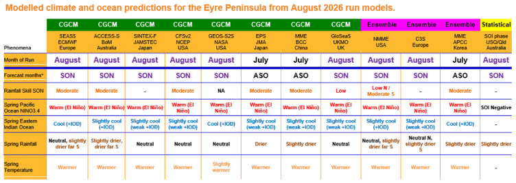
In the last two months a fully coupled El Niño has formed. The surface is 2.5oC warmer than normal in the central Pacific Ocean and the water to depth under this surface is much warmer than normal. In the atmosphere above, the winds are much stronger than normal westerlies in the western Pacific. The pressure is lower at Tahiti and higher at Darwin and the cloud at the international dateline junction with the equator is much greater and less over Papua New Guinea and Indonesia. All indicators point to a classically formed event. All models surveyed keep the event going until the end of the growing season and then through summer.
You would be hard pressed to think that this year’s El Niño is having the expected outcome historically or from the models. However, history and predictions all have an element of average or wetter outcomes being possible, albeit at lower chances. It appears this year’s growing season is likely to fall into the historically unlikely average to wetter, but not unprecedented.
The whole Indian Ocean is warmer than normal but there was a recent attempt to strengthen the easterly winds off Indonesia. This resulted in some cooler water off the island of Java and the Dipole Mode Index went to a positive Indian Ocean value. The cloud is vaguely reminiscent of +IOD but the winds have returned to normal and the pressure is not convincing. At the moment the African coast is showing no sign of wanting to be +IOD. All models surveyed predict a weak differential of normal/cooler water around Java/Sumatra and warmer water off Africa to continue for the rest of the growing season. It’s uncertain whether atmospheric coupling is also predicted, as currently it’s not. The most recent rainfall event arose out of the central Indian Ocean.
High pressure increased over July and early August and started to look more El Niño like. A cooler ocean to the north of Australia and higher pressure over SA are classic finger marks of El Niño’s trying to dry things up. Many models are predicting a continuation of stronger pressure over SA for the rest of the growing season.
Maximum temperatures have been closer to normal but minimum temperatures have been warmer over the last 3 months, speeding up crop development. Models predict warmer temperatures to continue for the rest of the year.
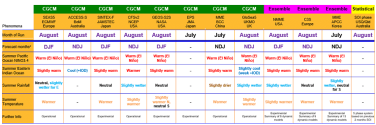
Over summer, models keep the El Niño going but historically El Niño’s have had variable rainfall results over summer but are historically warmer. The +IOD pattern is predicted to break down in November as is normal. Here the models diverge with around half coming in with wetter outcomes over summer being more likely. Hardly an eventuality we would desire during harvest.
The Sustainable Agriculture EP project is supported by the Australian Government through funding from the Natural Heritage Trust under the Climate-Smart Agriculture Program and delivered for the Eyre Peninsula Landscape Board, a member of the Commonwealth Regional Delivery Partners panel by AIR EP, EPAG Research, PIRSA and Ag VIC.
