RiskWi$e: Harvest reflections on seasonal forecasts and farm decisions
Andrew Ware, EPAG Research
As harvest gets underway across EP, growers are seeing how the season’s decisions have played out. Time in the header also provides a chance to reflect: what went well, what disappointed, and what might we do differently next time? Among those questions is how much influence seasonal forecasts had on the decisions made along the way.
Did expectations of below-average rainfall or warmer conditions affect crop choice, the fertiliser budget or the willingness to invest more as yield potential improved? Did the rainfall received and soil moisture in the paddock carry more weight? And, knowing what we knew at the time, would we make the same decisions again?
Much of a crop’s expenditure is committed around seeding, months before the spring finish becomes clear. Later decisions, such as topping up nitrogen or protecting yield potential, depend on both what happens next and the crop and soil moisture already in the paddock. Seasonal forecasts could help with those choices—but only if they provide useful information while there is still time to act.
The 2026 season provides a useful example. Discussion of El Niño and the prospect of a dry, warm finish sat alongside substantial rainfall across parts of EP, creating crop opportunities. For growers whose livelihoods depend on these decisions, that raises a reasonable question: how much weight should we give the local rainfall and temperature outlooks?
In this RiskWi$e article, we explore what seasonal forecasts can realistically tell us, why El Niño is only part of the picture, and when an outlook might justify changing a plan. As we reflect on this harvest and start thinking about next season, the aim is to assess whether forecasts helped us make better decisions with the information available at the time.
Most plans already have a starting point
A familiar starting point for a crop budget is recent average yield—say, the past five years. It draws on the farm’s results and can reflect gains in varieties, agronomy and soil improvement. Stored summer rainfall may then lift expectations before sowing. Five years can still contain an unusually wet or dry run, and past yields reflect constraints as well as potential.
The question is what this season adds to that baseline, and whether the local outlook changes the assessment enough to influence a decision still open.
This year the crop opportunity was already different
In our EP RiskWi$e work this year, Yield Prophet projections pointed to higher yield outcomes than usual where crops were sown in their optimal window and soils had the capacity to store—and crops to access—substantial summer moisture. That provided a paddock-specific reason to reconsider a budget based on recent average yields, before making any allowance for a seasonal forecast.
Yield Prophet combines soil water, nitrogen, sowing date and weather to date with possible seasonal finishes. Its standard approach uses historical weather sequences to generate a range of yields. A higher yield projection therefore does not, by itself, mean a wetter seasonal forecast. The soil profile, crop access and nitrogen assumptions remain important. [15]
Where seasonal outlooks fit in farm planning
What information was available around April sowing
The Bureau’s 9 and 23 April outlooks covered May–July. Both favoured warmer conditions across most of Australia. By 23 April, the rainfall summary identified increased dry odds in parts of eastern and south-west Australia, including south-eastern SA; most other areas had no clear wet or dry signal. That was not a blanket dry forecast for EP, nor a forecast of the September finish. [13]
In April, it is still difficult to predict whether El Niño will develop and what it might mean for spring. Some local rainfall and temperature forecasts are more reliable than others, so confidence in the outlook matters as well as what it predicts. Looking back at sowing, how much useful information did the forecast add to what growers already knew about stored soil moisture and the opportunity for timely sowing? [10, 11, 14]
A wet winter and a warmer dry September
Winter rainfall reached 243 mm at Cummins Aero, against a mean of 186 mm, and 196 mm at Minnipa PIRSA, against 110 mm. September then delivered just 13 mm and 6 mm respectively. Minnipa’s September mean daily maximum was 23.4°C, reported by the Bureau as 1.6°C above average. [1]
Stored water could buffer the rainfall shortfall, while warmer conditions could accelerate development and shorten grain fill. Both could occur in a season with high yield potential. September alone cannot verify an April outlook for May–July or establish the cause of a crop’s final yield.
The same outlook can mean different things for nitrogen
Two crops with similar original budgets may enter winter with very different water reserves and yield prospects. An increased chance of below-median rain could strengthen the case against extra nitrogen in one, while the other still presents a worthwhile opportunity. Where the same option performs well across poor, middle and favourable finishes, the forecast may add little. Where the choice is finely balanced, a credible shift in the odds could matter. [9]
For example, a 70% chance of below-median rainfall still leaves a 30% chance of above-median rain; it does not mean 70% less rain. A 50:50 outlook does not promise an average season. Temperature probabilities likewise do not predict the dates or severity of individual heat events. [11]
History offers a useful example. During the 1951–52 El Niño, southern SA received average to above-average rainfall, with exceptionally wet conditions between April and August 1951. [8] Although this was not a test of a 70:30 forecast, it illustrates why an El Niño label does not rule out a wet season.
Could the headlines be shaping expectations?
Hayman and Cooper discuss how media coverage can simplify climate drivers into expectations that a season will be wet or dry. [5] Repeated El Niño or “hot, dry spring” headlines may influence expectations even where forecasts are not formally used in budgets.
An early “dry year” expectation can become an anchor: later rain may be treated as an exception, while information confirming the original view attracts more attention. Wet-season optimism and dismissing every forecast can also shape judgement. These are possible influences, rather than evidence of biased decisions by EP growers this year.
Reflections from the header
How did the plan based on recent average yields evolve as the season unfolded? Did measured water and Yield Prophet projections change expectations? Did the local outlook add useful information or mainly colour the way other evidence was interpreted? The information available at the time provides a fairer basis for reflection than the harvest result alone.
Rainfall context and further reading
El Niño is one influence on EP rainfall
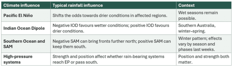
These influences interact. A warm Indian Ocean alone does not establish a negative IOD. The local rainfall outlook combines multiple influences and is more relevant than an El Niño headline. [2–4, 10] SARDI’s analysis of eight EP sites found a stronger historical shift towards wet springs in negative IOD years than in La Niña years. This does not make the IOD dominant every year. [7]
Wet winter followed by dry September
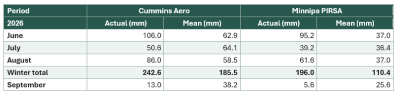
Bureau station means use available records excluding 2026; they are not medians or a common 30-year baseline. Winter totals sum June–August. Stations: Cummins Aero 018217; Minnipa PIRSA 018195. October is incomplete. Rainfall totals do not measure plant-available water. Minnipa’s +1.6°C anomaly is the published September figure; the live all-years table now lists a 21.9°C mean, so these baselines should not be mixed. [1, 16]
Forecast skill and the sowing decision
Forecast probabilities and past accuracy describe different things. Accuracy varies by location, target months and lead time, and is assessed across many years. The chance of El Niño developing is a separate probability; a September outcome cannot verify a May–July outlook. [11]
Sources and local updates
- Bureau SA summaries: June | July | August | September 2026
- Bureau: Indian Ocean Dipole
- Bureau: Southern Annular Mode
- Bureau: Subtropical ridge and rainfall
- Hayman and Cooper (2021): Seasonal forecasting and media framing on EP
- AIR EP: Dale Grey’s August 2026 video update (historical outlook)
- SARDI (2020): Climate information for eight Resilient EP reference sites
- BOM: ENSO history—1951–52 El Niño and rainfall in southern SA
- GRDC (2021): Hayman on using climate outlooks in decision analysis
- Bureau (2026): Why the long-range forecast matters alongside El Niño
- Bureau: Understanding rainfall and temperature probabilities
- Alexander and colleagues (2010): Heat stress and crop timing in South Australia
- a. Bureau May–July outlook issued 9 April 2026 b. Bureau May–July outlook issued 23 April 2026
- Bureau: Autumn predictability barrier and ENSO outlook skill
- Yield Prophet: Crop simulations and yield probabilities
- Minnipa PIRSA: Live all-years climate statistics